R4
Tauro - La Solana
Condition: Good state of conservation. Pay attention to the cairns to avoid getting lost. Beware of sunstroke and cliffs (vertigo).

Features
11,9 km
Distance
7h
Duration
High
Effort

Description
Section A: Salto del Perro Dam-Degollada de Las Lapas:
This starts on the road from Ayacata to Barranquillo Andrés (past the Las Niñas dam and the Cruz de San Antonio) or from the Mogán bank via Albarianes. The entrance to the path is clearly marked by a cairn. We start the ascent up the Tauro Mountain until we reach the Fuente del Durazno (a wide esplanade that opens up at a bend in the path). From this point, the zigzagging ascent takes us to the summit, with the option of approaching the Almogarén or Tagororor, along a path on our left. The route continues gently downhill to Degollada de Las Lapas, where there is an old abandoned forestry house used as a shelter for rangers and shepherds. This pass is a crossroads of paths: to the SW, the path to the Llanos del Guirre (Laderones/Molino de Viento, Hoya del Salitre) and to the E, leaving behind a first milestone next to the house, we come to another milestone, about two hundred metres along the Cañada de la Salvia, which points us in two directions: heading E, we connect with the path to Cortadores, and heading S, we head towards the Llanos de Gamona.
Section B: Degollada de Las Lapas – Llanos de Gamona:
The path is flat and clearly signposted, continuing on a gentle descent to reach the Lajas de Medina, where we can see piles of stones (slabs) that may confuse us with the cairns that mark the path (caution), until we reach the Llanos de Gamona. Here we come across a dirt track for private use coming from the mouth of the Bco. de Tauro. At the end of this section, we can also see the milestone that announces a new crossing of paths: to the W, the path that goes to the Llanos del Guirre, crossing the Taurito Bank, and to the E, the path that goes down the impressive Tauro Bank, towards the Tauro Houses.
Section C: Llanos de Gamona – Casas de Tauro:
Clear and very comfortable path towards the ravine until we cross a platform, from which the steep zigzagging slope leads us to a canal (pipe). We continue, guided by the cairns, down another steep slope to a gully with abundant vegetation, which leads us to another platform with a steep zigzag carved into the rock.
We continue down a slope, crossing zigzagging ravines and paying careful attention to the cairns that show us the way (a rocky area full of vegetation) until we reach a dirt track that leads us to the Casas de Tauro Alto (cairn two hundred metres above the Casas).
Section D: Casas de Tauro – Degollada de Cortadores:
From where the previous section ends, descend a little to the abandoned houses, surrounded by some pines and palm trees, continuing along the track on the left. It flattens out until it connects with another, which we take again to the left and uphill, to reach the Embudo Dam. Once you leave the dam behind, continue along the path marked by cairns along the bed of the Tauro ravine. You can see plants on the rocks, such as mamitas, cruzadillas and some brooms and junipers. Further on, you will see pines, eucalyptus, tabaibas, reeds and rockroses. Once you come to the signpost, the route starts to climb up the right bank of the ravine and crosses a number of hills and gullies as you ascend. The ascent continues zigzagging towards the Degollada de Cortadores, with vegetation of rockroses, lavender, thyme and tabaibas. The surface of the path in this part is stony, although it is wide and well signposted. The section ends ascending to the Degollada de la Cochina and, a little further on, to the Degollada de Cortadores (pay attention to the signposting).
Section E: Degollada de Cortadores- La Solana:
We leave behind the first signpost that we find when we reach the Degollada de Cortadores, in front of the house of the Comunidad de Regantes and cross the plain towards the E, in the direction of the Arguineguín ravine, where we see another signpost that indicates the beginning of the path towards the Degollada de Las Lapas (parallel to the canal) and towards La Solana. We start to descend a small slope, paved later in a zigzag. The path is clear and wide, except for some sections with thick vegetation (reeds and rushes), and a small narrowing in a rocky area: be careful on the platform and on another part of the path that crosses an area of debris. Before a small ravine, we have to negotiate large boulders and a pipe in the middle of the path. We then reach a fruit farm with a house on the top and a track that goes up from the main road. Near the house there is a milestone that marks the path to the left to continue on the flat, between pines and cactus trees. A little further on we join the Arguineguin-Cercados de Espino-Soria road, approximately one kilometre from Barranquillo Andrés.
Interpretation:
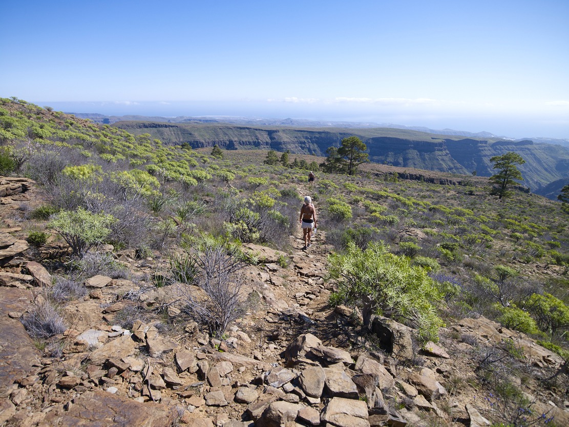
We leave the Salto del Perro dam behind us, to take the path that climbs Mt. de Tauro. Early in the morning, the mountain will appear to us like a sleeping giant that is beginning to wake up; the lower half in shadow and the upper half in reddish colour, in contrast with the bright green of the pines, due to the sunrise.
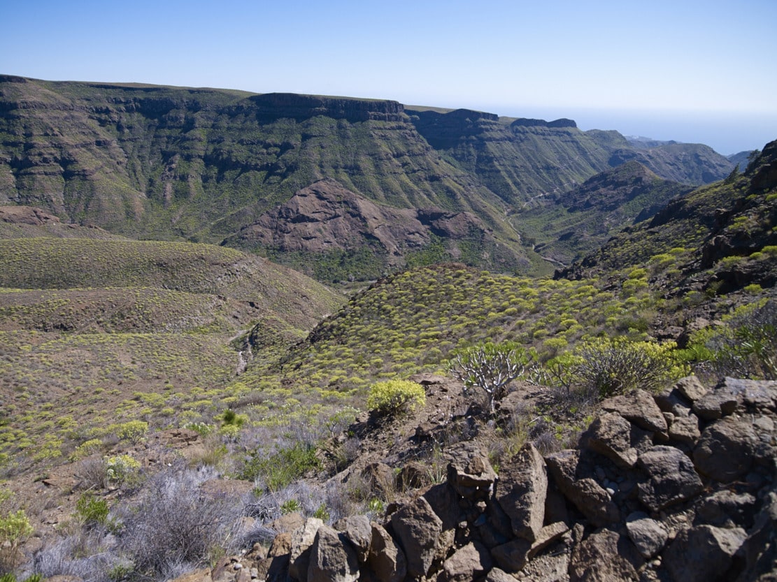
When we reach the top of the Fuente del Durazno, we can stop for a moment to stretch out and enjoy a magnificent panoramic view (almost circular) crowned by the head of Mogán Bank, with the Mt. de Aslobas and the Teide in the background up to the Santidad ramp, to the SE. In the foreground, filling the space between the Inagua-Ojeda-Pajonales Massif and the Tauro Ramp, we can see the Majada Alta plains.
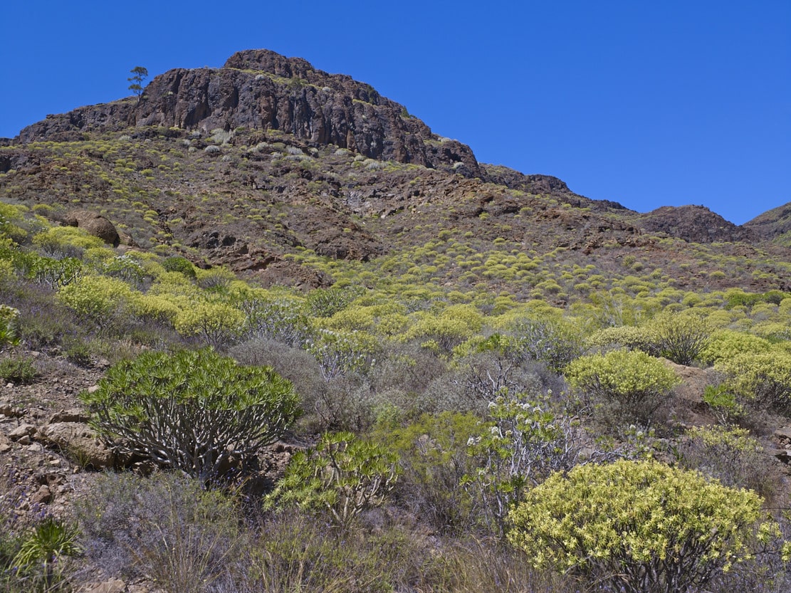
We continue our ascent to the mountain along a relatively narrow path, first among scrubland (cardonal-tabaibal) and, as we approach the summit, among pine trees. The “lágrimas de la virgen”, with their characteristic little white flowers, stand out in the undergrowth. Witness to the forestry activity of the past, on the left of the path you will find the remains of a pitch oven, where the resin from the bark of the pine tree was used to obtain pitch or pitch for caulking ships. Near the summit, we can also make out the Guguy Massif, with the Hogarzales Mountain and the Cedro Mountain in the background towards La Aldea. If we visit the site of “La Iglesia de los Canarios” (we must be as respectful as possible), we will be able to understand the more than probable religious meaning of the site, due to the mysticism of the place, with a very beautiful panoramic view. Back on the path, from the stone wall that shows us the way, we can see towards the sea, the whole ramp that opens up in a fan, with the great plains interrupted (del Guirre, to the W, and Gamona to the E), by the incision of the ravines of Taurito and Tauro.
As we leave Mt. de Tauro, the pine forest opens up, leaving “patches” of pine trees, some of which are also loose or in pairs. And once again the bushes begin to appear; now the cardoncillos stand out, all along the ramp, with their characteristic greyish green colour. But the most curious and outstanding feature of the path are the flagstones, produced by the erosion of the trachyphonolitic material of the ramp, which will also accompany us on practically all the paths along the ramp, like a little music caused by the percussion of our footwear against the ground. This sound gives rise to the name of these rocks: phonolites (“fono”=sound, “lita”=stone).
After a moderately steep but short descent, you will reach the Degollada de Las Lapas. On the right hand side, some fifty metres to the W after the half-ruined house, there is a balcony or viewpoint towards Mogán (beware of the precipice and vertigo). A typical characteristic of the cut-throat areas is the whip of the wind that blows from one slope to the other, making the contrast between one slope and the other more noticeable.
Heading towards the Llanos de Gamona, we go round the Cañada de Las Lapas (head of the Taurito bank), among pine trees, to continue along a small knife, which allows us to look out and see the large gorge caused by the incision of the Tauro Bank. This narrow spine widens further on, forming large plains (called “lomos amesetados”), known as the Lajas de Medina and the Llanos de Gamona, in which, as their names indicate, what predominates in the former is a landscape of rocks dotted with cardoncillos, tabaibas and taginastes; and probably, the name “Gamona” of the latter plain refers to the presence of this plant associated with the pine forests. From the Lajas de Medina there is a good view of the lower part of the ramp and the coastal towns (Arguineguín, Puerto Rico) can be seen in the distance.
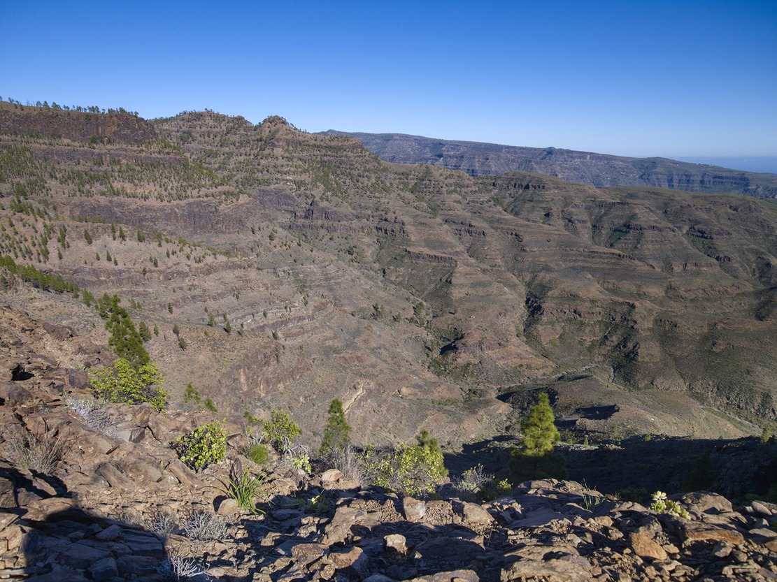
We are now entering the heart of the area, as we descend the Bco. de Tauro in the direction of Cortadores. We will enjoy a unique panoramic view as we cross it, walking along its steep slopes. -Another hidden place in Gran Canaria, where we will have the sensation of being “in another world”, due to the silence and the abruptness of the terrain. As we cross the riverbed, we find more developed vegetation (cruzadillas, cerrajas de risco, sabinas, etc.). We first pass through the village of Casas de Tauro Alto, of great ethnographic value, formed by the traditional houses of an old livestock farm, now transformed into a nursery of ornamental plants privately produced for the tourist sector. A little further up is the Embudo reservoir, with a small capacity, where migratory birds such as herons flock. We will also find or hear partridges, much appreciated by hunters in the area.
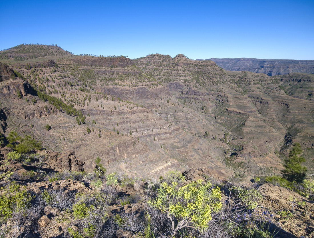
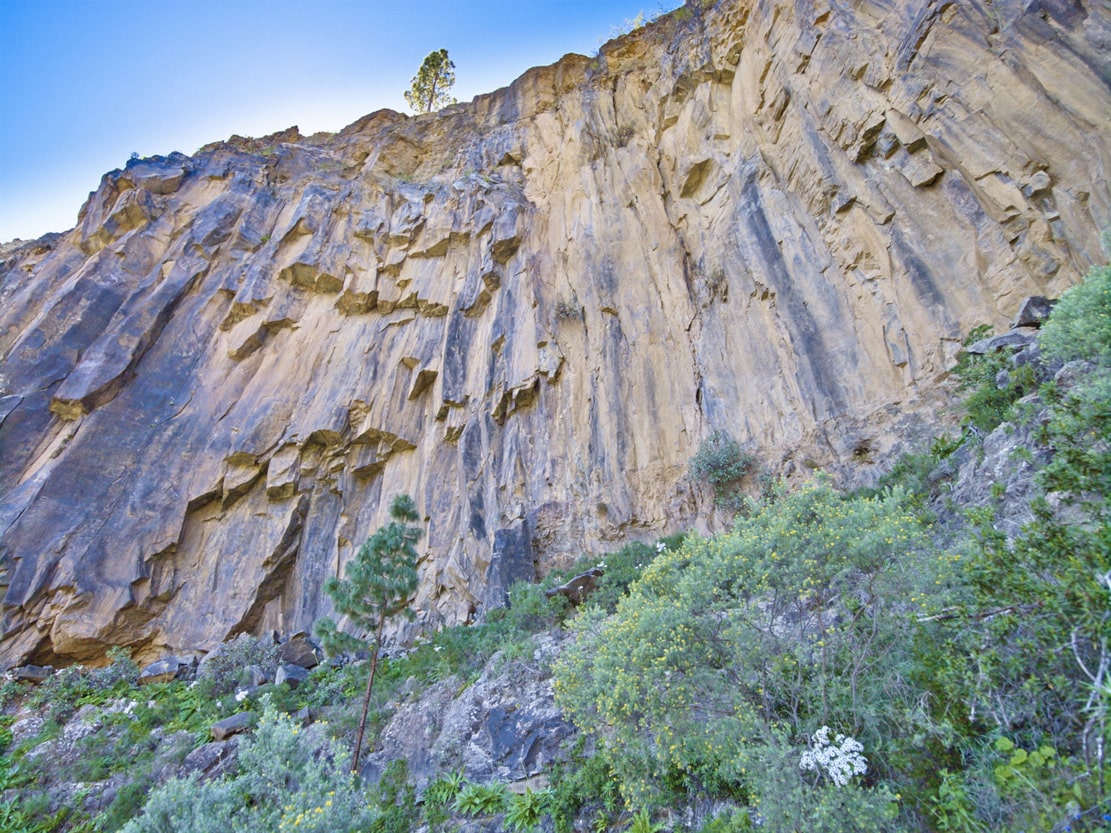
On the hard climb up to Cortadores, we can enjoy the view of the headwaters of the Bco. de Tauro, known as the Caideros* de Tauro. The different tributaries (ravines) that form it “bite” the ramp, producing large cuts or cliffs, such as the Caidero Colorado – so called because of the colour of the stone -, which indicate intense erosion processes due to large runoffs* in rainier periods than the present, although erosion continues, due to the presence of sporadic but torrential rains. We will also go round the headwaters of the Tangüingüe-El Lechugal riverbed.
We reach another of the great plains of the ramp: Cortadores. Its name refers to the felling or cutting of pine trees. Nowadays there is an enormous solitary one, which provides good shade for walkers. In Cortadores there is a nucleus which can be accessed by track, for residential use and with active farms, threshing floors, alpendres, etc. Historically, this nucleus has always been important because it was home to the Tauro livestock herd. This livestock use may explain, in addition to the forest felling, the absence of significant vegetation, as it is a pasture area.
We are now on the E side of the Tauro Ramp, which looks towards the Arguineguín Bank. This is the beginning of the descent and the end of this route. A few metres from the start, the panoramic view opens up with the central summit of Gran Canaria in the background, the villages of Soria with the dam and Barranquillo Andrés, the Lomo de la Palma and the villages of La Higuerilla, Las Filipinas and Cercados de Espino in the Arguineguín riverbed.
The first section of the path (El Palmarete), has cobbled parts (old bridle path). Then we continue along a narrow path along the cliffs. It is worthwhile to look in the direction of the summit and see the different terraces that erosion has created on Tauro Mountain. Looking up, we can see enormous bare walls like quarry blocks, with some rock species (cerrajas), taking advantage of the erosive cracks in them. Downwards (beware of vertigo) we can see the old path in disuse, very deteriorated due to the continuous landslides that also affect the current path. After leaving the platform, the path becomes smoother and we can enjoy the vegetation, which is more lush on this shady slope. It is worth trying to recognise them, because there is a great variety of all the species mentioned: rocky species, species of the degradation of the pine forest and the thermophile (dragon trees and junipers) and species of the Cardonal-Tabaibal. The path ends about 300 metres after the Finca de la Solana, a traditional and active farm. There you will see peacocks and African hens next to the fruit trees (please respect private property).